


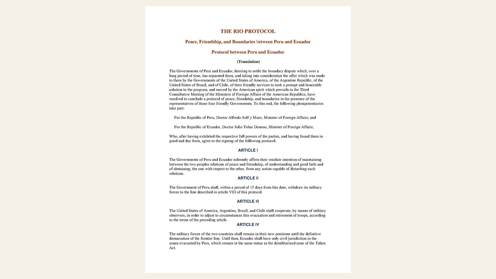
At Rio de Janeiro, on 29 January 1942, at one o’clock, the Governments of Peru and Ecuador sign the Protocol of Peace, Friendship, and Boundaries, in the presence of the representatives of the United States of America, Argentina, Brazil, and Chile. For Peru, Alfredo Solf y Muro, Minister of Foreign Affairs, signs; for Ecuador, Julio Tobar Donoso, Minister of Foreign Affairs. The instrument is done in two copies, in Spanish, under the auspices of the President of Brazil and in the presence of the Ministers of Foreign Affairs of Argentina, Brazil, and Chile and of the Under Secretary of State of the United States.
The preamble records the desire to settle the long-standing boundary dispute, takes into account the offer of friendly services by the four friendly Governments, and is moved by the American spirit of the Third Consultative Meeting of the Ministers of Foreign Affairs of the American Republics. The plenipotentiaries, after exhibiting their full powers and finding them in good and due form, agree to sign the protocol.
Article I affirms the Parties’ resolute intention to maintain between the two peoples relations of peace and friendship, understanding and good faith, and to abstain from any action capable of disturbing such relations. Article II requires Peru, within fifteen days from this date, to withdraw its military forces to the line described in Article VIII. Article III provides that the United States, Argentina, Brazil, and Chile shall cooperate, by means of military observers, in adjusting the evacuation and retirement of troops.
Article IV requires the military forces of both countries to remain in their new positions until the definitive demarcation of the frontier; until then, Ecuador shall have only civil jurisdiction in the zones evacuated by Peru, which remain in the same status as the demilitarized zone of the Talara Act. Article V continues the activity of the four guarantors until demarcation is completed; the protocol and its execution stand under the guaranty of the United States, Argentina, Brazil, and Chile.
Article VI grants Ecuador, for navigation on the Amazon and its northern tributaries, the same concessions which Brazil and Colombia enjoy, in addition to those which may be agreed in a Treaty of Commerce and Navigation designed to facilitate free and untaxed navigation on those rivers. Article VII refers any doubt or disagreement arising in the execution of the protocol to settlement by the parties concerned, with the assistance of the representatives of the four guarantors, in the shortest possible time.
Article VIII fixes the boundary line on western points — from the mouth of the Capones in the ocean, along the Zarumilla, the Puyango or Tumbes, the Chira, the Macará, Calvas, and Espíndola to the Nudo de Sabanillas, then the Canchis and the Chinchipe to the San Francisco — and on eastern points — the watershed between the Zamora and Santiago, lines involving the Pastaza, Tigre, Curaray, Napo, Aguarico, Lagartococha or Zancudo, Güepí, and Putumayo up to the Ecuador–Colombia boundary. Article IX provides that the described line shall be accepted for demarcation on the ground by technical experts, and that reciprocal concessions may adjust it to geographical realities with the collaboration of the representatives of the four guarantor States.
The Governments of Peru and Ecuador shall submit the protocol to their respective Congresses and obtain approval within not more than thirty days. Sumner Welles, Enrique Ruiz Guiñazú, Juan B. Rossetti, and Oswaldo Aranha also sign as guarantors. The text is not the 1934 Rio Protocol between Colombia and Peru.
Image: first page of the English translation of the Rio Protocol (1942), Wikimedia Commons / public domain (UN document). Framed to 16:9.
Source consulted: Rio Protocol. Treaty text: The Rio Protocol — Peace, Friendship, and Boundaries between Peru and Ecuador (English), UN Peacemaker.



0 Comments
No comments on this article yet. Be the first!